


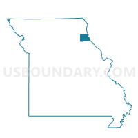
PAHA Voting District, Marion County, Missouri
About
Outline

Summary
| Unique Area Identifier | 609076 |
| Name | PAHA Voting District |
| County | Marion County |
| State | Missouri |
| Area (square miles) | 18.12 |
| Land Area (square miles) | 17.95 |
| Water Area (square miles) | 0.17 |
| % of Land Area | 99.06 |
| % of Water Area | 0.94 |
| Latitude of the Internal Point | 39.79499660 |
| Longtitude of the Internal Point | -91.45808210 |
Maps


Graphs
Select a template below for downloading or customizing gragh for PAHA Voting District, Marion County, Missouri


Neighbors
Neighoring Voting District (by Name) Neighboring Voting District on the Map
- Mt. Zion Voting District, Marion County, MO
- PACO Voting District, Marion County, MO
- PASH Voting District, Marion County, MO
- West Ely Voting District, Marion County, MO
Top 10 Neighboring County Subdivision (by Population) Neighboring County Subdivision on the Map
- Miller township, Marion County, MO (5,997)
- Liberty township, Marion County, MO (4,500)
- South River township, Marion County, MO (369)
Top 10 Neighboring Place (by Population) Neighboring Place on the Map
Top 10 Neighboring Unified School District (by Population) Neighboring Unified School District on the Map
Top 10 Neighboring State Legislative District Lower Chamber (by Population) Neighboring State Legislative District Lower Chamber on the Map
Top 10 Neighboring State Legislative District Upper Chamber (by Population) Neighboring State Legislative District Upper Chamber on the Map
Top 10 Neighboring 111th Congressional District (by Population) Neighboring 111th Congressional District on the Map
Top 10 Neighboring Census Tract (by Population) Neighboring Census Tract on the Map
- Census Tract 9604, Marion County, MO (4,510)
- Census Tract 9601, Marion County, MO (4,339)
- Census Tract 9603, Marion County, MO (3,631)